Ebay banner

Showing posts with label walking. Show all posts

Tuesday, 9 January 2024

An Urban Wander from Deptford to Greenwich

 Until recently I'd never really spent any time in Deptford in South London. However, of late, thanks mainly to the wonderful Upsidedown record shop on Deptford High Street, I've made a couple of visits. This blog post features some pictures and commentary from a recent urban wander I did, starting in Deptford, walking along the Thames path to Greenwich.

First up we have Manze's meat pie shop on Deptford High Street. I was immediately drawn to this shop by its wonderful signage. Many shops that have similar signage have long since been re-purposed but it was good to see that Manze's is still an active pie shop, and has been since 1902 apparently.

Manze's meat pie shop, Deptford High Street, South London

Manze's Meat Pie Shop, Deptford High Street, South London

Also on, or rather just off, Deptford High Street, are a couple of old signs, pointing people in the direction of the nearest air raid shelters in which to take cover during World War II. The first one looks as though it could still be the original one, although a shame about the 'alteration'. The second has clearly been restored at some stage.

Former air raid shelter sign, Deptford, South London

Former air raid shelter sign, Deptford, South London


Former air raid shelter sign, Deptford, South London

Former air raid shelter sign, Deptford, South London

As I headed north out of Deptford to the river I came across this wonderful piece of graffiti, 
STEVE NOLLER WEARS FLARES
which is perhaps the ultimate insult, or not.

Graffiti, Deptford, South London

Graffiti, Deptford, South London

Beyond the graffiti, the road narrowed and turned into a narrow, cobbled street, aptly named Watergate Street, leading to the River Thames.

Narrow, cobbled path leading out from Deptford to the River Thames

Watergate Street leading out from Deptford to the River Thames

Although most of November and December 2023 were just grey and wet, I was fortunate enough to be walking on one of  the rare, cold and clear days. As Watergate Street reached its end, it opened out on to the river, affording some impressive views. I always find Canary Wharf quite soulless when I'm there, but seen from a distance it is quite impressive, particularly against the beautiful blue sky.

Canary Wharf as seen across the River Thames from Deptford

Canary Wharf as seen across the River Thames from Deptford

Just along the Thames is the former Paynes Paper Wharf building, which is now some sort of design studio. It's hard to make out in this picture but the lettering of its former purpose can just be seen above the arched windows, which incidentally are the only remaining feature of the original building. There are some pictures showing it in various stages of renovation here. 

The former Paynes Paper Wharf building

 The former Paynes Paper Wharf building

As the walk continued along the Thames I came across the southern entrance to the Greenwich foot tunnel, engineered by Alexander Binnie and opened in 1902, which takes pedestrians and bike beneath the river to Island Gardens on the north side.

Southern entrance to the Greenwich foot tunnel

Southern entrance to the Greenwich foot tunnel

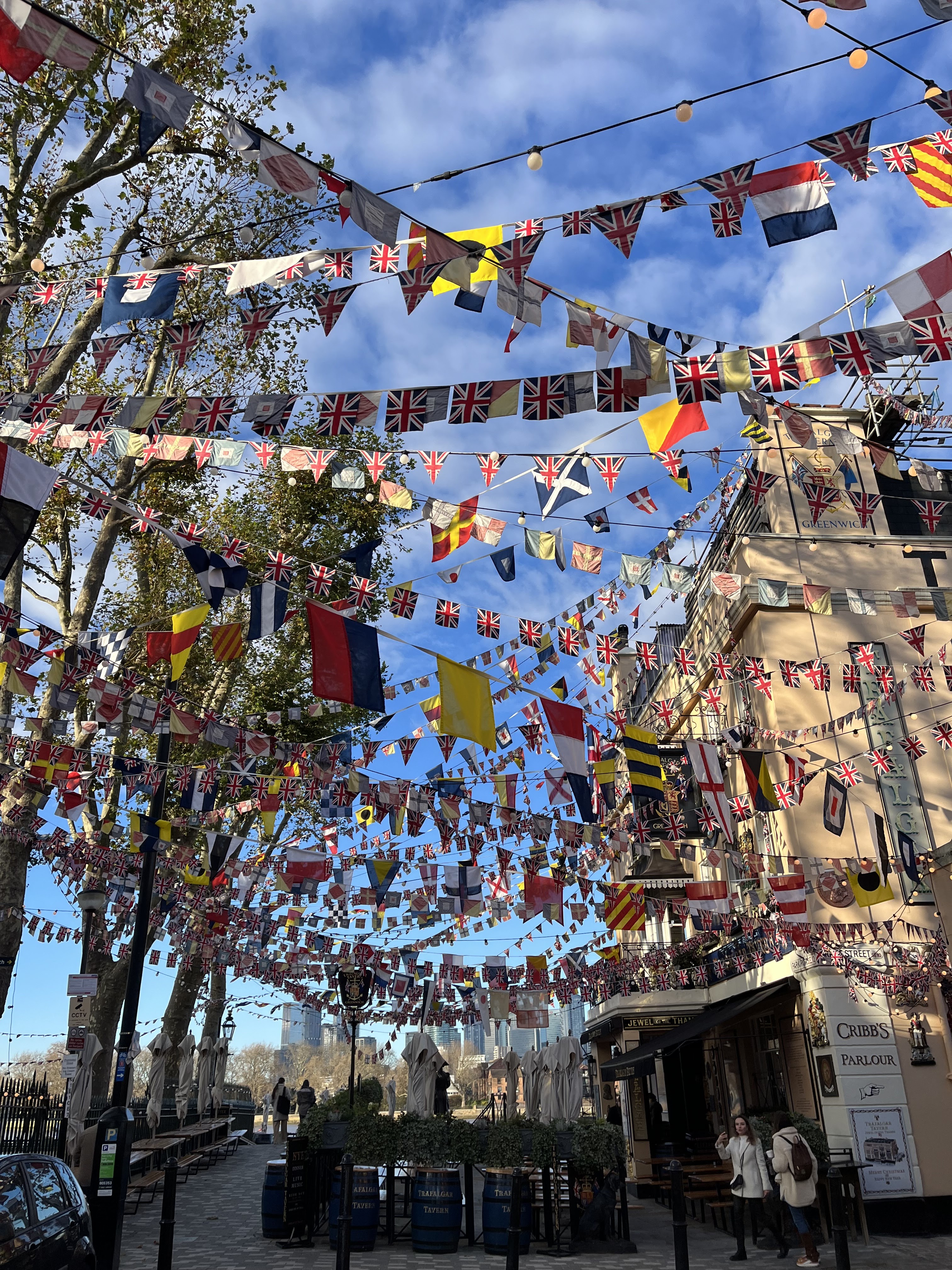
Having been to Greenwich itself many times before, I didn't really stop there but as I reached its eastern edge, I came across the Trafalgar Tavern, looking resplendent with all the flags blowing gently against the backdrop of Canary Wharf in the winter breeze.

The Trafalgar Tavern, Greenwich, South London

The Trafalgar Tavern, Greenwich, South London

Beyond the more commercial part of Greenwich is the former Greenwich power station and its former coal jetty. London's lost power stations have such a rich history, much of which is lost but some still remains for the curious explorer. Inspired by this, and my visit to similar sites such as the Lots Road power station, I bought a book on London's Lost Power Stations and Gasworks, by Ben Pedroche, which I can highly recommend for anyone with a thirst for industrial history.

https://www.geograph.org.uk/snippet/5043

Former coal jetty at Greenwich power station

Further along the river, beyond Greenwich is the former Harbour Master's Office. 

Former Harbour Master's Office, Greenwich

Former Harbour Master's Office, Greenwich

And finally in this post, a view across the River Thames, taken as the sun was beginning to set.

View across the River Thames from Greenwich

View across the River Thames from Greenwich

Many thanks for reading this post. Hopefully I will continue to post new material on a more frequent basis than recently.


Saturday, 28 January 2017

A lunchtime wander around the other end of Hook, Hampshire

Before we get into the pictures, I have become a bit curious about Hook as it's quite an odd place. Thousands and thousands of houses, only a few shops, and a relatively small train station at which the central platforms have been removed a while back, leaving just two remaining platforms, and many trains simply spped through on their way to London or Exeter, and do not stop there. I've come across a book called The Planning of a New Town written in in 1961 which describes a private new town, sponsored by the London County Council (LCC), to be built at Hook in Hampshire; a scheme that innovatively combined Garden City/New Town traditions with sensitivity to modern design. It would not appear though that the Hook of today is a result of this study, and that perhaps efforts were diverted to Basingstoke instead. Anyway, on with the show ...

Following on from my earlier wander around the less well trod paths surrounding Hook, today I wandered in the opposite direction, south along Holt Lane until it petered out into footpaths, eventually reaching and crossing over the busy M3 motorway. The day was bitterly cold but gloriously sunny. The ground was frozen and crisp underfoot, with just a few sticky patches where the weak sun had managed to thaw out some of the frozen mud.

Looking south along Holt Lane, Hook, Hampshire

As the lane became thinner it was not particularly obvious where the path went until I caught sight of a footbridge in the distance. A tranquil walk interrupted rudely by the noisy motorway.

Footbridge over the M3, Hook, Hampshire

Annoyingly I didn't manage to capture this view of the footbridge very squarely, but an interesting contrast between the clear blue sky and turquoise railings of the bridge.

Footbridge over the M3, Hook, Hampshire

After crossing the bridge there were a couple of footpaths I could have taken, but lunchtime was running out, and also they looked a bit muddy to attempt in my work attire, so I headed back north the way I had come. If I'm still working here later in the year then maybe there will be more options open to me in the drier weather.

Looking north along Holt Way, Hook, Hampshire

  ;  

Thursday, 7 April 2016

A Suburban Wander from Moor Park to Stanmore, following the London Loop

As hinted at in my previous post, a Suburban Wander from Harefield to Moor Park following the London Loop, I was unsure where my next wander would take me. Having just finished Gareth Rees' wonderful Marshland I really wanted to explore the Walthamstow, Hackney and Leyton marshes, but that will have to wait until another day. Instead we embarked on our second part of the London Loop recreational path, from Moor Park to Stanmore, some of which is featured in Nick Papadimitriou's Scarp, another excellent, recent read.

We drove to the Northwood/Moor Park border, looking for somewhere to park that was not too much of a trek from the start of the walk, and eventually ended up reasonably close to Moor Park station. The weather was stunning, but as you'll see from the later pictures, this was not to be sustained for the whole day's walk.

Bridge carrying the Metropolitan railway line at Moor Park

The first section of the walk took us across open fields, strewn with electricity pylons disappearing off into the distance, as we headed to the Sandy Lodge Golf course.

Electricity pylons disappearing off into the distance, Moor Park

Electricity pylons disappearing off into the distance, Moor Park

Electricity pylons disappearing off into the distance, Moor Park

 Keeping an eye out for stray golf balls whizzing through the air, we navigated the greens and golfers and came out on to Sandy Lodge Lane.

Sandy Lodge Lane, Moor Park

After Sandy Lodge Lane, the route took us through parkland and woodland. I seem not to have taken any pictures through Oxhey Woods for some reason, most likely because the going was difficult and we had to carefully place each foot to avoid slipping over in the ever present mud. However, the mud in the woods was nothing in comparison to the mud which greeted us as we came out of the woods and into open fields somewhere near Hatch End. The fields had been churned up by horses and several times we found ourselves over ankle deep in wet mud. There was certainly no scope for taking pictures during this part of the wander. However, once we had successfully negotiated the mud, but alas with wet feet, we emerged on to a more solid path, where this beautiful farmhouse stood, hiding the quagmire in the distance.

Farmhouse, near Hatch End, on the London Loop Recreational Walk

From here the path followed a few more wet, field edges and then skirted between fields and housing estates on narrow tracks. If I'm honest, we were getting quite fed up with walking on wet and muddy tracks so we quite pleased when we eventually found some more solid ground.

Bridge crossing the main line from Euston, near Carpenders Park

Bridge crossing the main line from Euston, near Carpenders Park

Unlike our previous section of the loop, we did not come across much in the way of villages, towns or country pubs, so had to make do with having a late lunch in a garden centre, which I desperately try and avoid at all costs as it makes me feel I'm turning into my parents, but needs must, and we were getting quite hungry. Sustained with home-made soup, followed by tea and quite a wonderful cream egg brownie, we set off again towards our destination. My feet had almost dried out too, so the walk was a bit more comfortable, although my boots, socks and trousers were covered in mud.

Again we trekked through woods and commons, passing through Grim's Dyke, Harrow Weald Common, and Bentley Priory. The weather has closed in a bit by this stage, so once again there was a lack of photo opportunities. The few I did take however were around Grim's Dyke, a 2,000 year old ditch, which surrounding area also boasts the house and gardens formerly owned by Sir William Gilbert, of Gilbert and Sullivan fame, who drowned in one of his lakes trying to assist a female house guest who had got into trouble.

Lake in the gardens of William Gilbert's former house

Gilbert's house is now a hotel.

William Gilbert's former house

William Gilbert's former house

Derelict building, near Bentley Priory

Once again we seemed to have either over exerted ourselves, or under estimated our strength and stamina, and were feeling quite weary by this stage. The walk through Stanmore Common and down to Stanmore tube station was quite a slog, and we were glad to find some shops for our second cake of the day, which we bought from Lidl and ate on the tube as our clothes were so muddy we felt in no fit state to go into a cafe.

Whilst the section of the loop we had followed was enjoyable, we both agreed that it was less enjoyable that the first section we'd walked from Harefield to Moor Park. I suspect this was mainly to do with the mud, and later in the day the weather. However, we are not put off, and will return at some stage to start the next section. But before that, I have a more recent urban wander to post.


Tuesday, 22 March 2016

A Suburban Wander from Harefield to Moor Park, following the London Loop

As mentioned in my previous blog post, a Suburban Wander from High Barnet to Cockfosters, having seen it sign posted I hinted that I would one day undertake a more structured walk, as opposed to a drift, along the London Loop route. Well, this event has happened far sooner than I ever anticipated it would. I won't go into the reasons here but needless to say I was delighted to find myself with an opportunity to at least make a start on this circumnavigation of the London suburbs.

Living about an hour west of London, on the Berkshire/Hampshire border, we decided to start our first leg as close to home as possible, and travel there and back by car, as opposed to travelling in and out of London by public transport. The route, it would seem from the London Loop guide book we read, is aimed at people living in London who may not necessarily be aware that there is countryside just on the city's doorstep, so travelling to and from the walk makes sense with a zone 6 rail card. After having read this, and given that we live in the countryside, I was not sure whether the route would have the same effect on us, as we really are spoiled for access to the great outdoors here. However, we were not disappointed and the edgelands mix of urban, suburban and rural landscapes worked perfectly.

The location closest to us was Harefield, which has a secondary interest to me as I grew up in Ruislip and this was somewhere I used to go canoeing with the Sea Scouts when I was about 11 or 12, although I moved to the Cotswolds shortly after that so did not canoe there for very long and was hard pressed to pinpoint exactly where I used to go. So, off we set, down the M4, across on the A404 to join the M40 and on towards London, turning off to Harefield not long after the M40 turned into the A40. Our starting point was the Grand Union Canal on a rather grey and dreary day, which was a little disappointing after the previous days of sunshine.

Grand Union Canal, near Harefield, on the London Loop Recreational Walk

Grand Union Canal, near Harefield, on the London Loop Recreational Walk

Grand Union Canal, near Harefield, on the London Loop Recreational Walk

Grand Union Canal, near Harefield, on the London Loop Recreational Walk

The section of the route we walked was well sign posted on the whole, but there were a few parts later on when we navigated our way between electricity pylons before we reached Moor Park where some new markers had just been put up by a warden which seemed to point in the wrong direction. Fortunately our gut instinct and guide book helped us find the right path, plus the fact that one sign in particular was pointing at something quite impassable.

Waymarker for the London Loop Recreational Walk, near Harefield

Grand Union Canal, near Harefield, on the London Loop Recreational Walk

Grand Union Canal, near Harefield, on the London Loop Recreational Walk

I'd never heard of Braunston, and even an internet map search took a while for me to determine exactly where it was. It seems to be almost in the middle of nowhere, sat diagonally between Coventry and Northampton. There's a marina there which would explain the mile post and in fact it's at the junction of the Grand Union and Oxford canals, so at one time quite an important junction for commercial, canal traffic. From the little internet reading I did, it still seems to be a bustling marina but now serving more of a recreational purpose.

Mile post for Braunston, on the London Loop Recreational Walk
Mile post for Braunston, on the London Loop Recreational Walk

Grand Union Canal, near Harefield, on the London Loop Recreational Walk

Grand Union Canal, near Harefield, on the London Loop Recreational Walk

Grand Union Canal, near Harefield, on the London Loop Recreational Walk

Grand Union Canal, near Harefield, on the London Loop Recreational Walk

Grand Union Canal, near Harefield, on the London Loop Recreational Walk

Grand Union Canal, near Harefield, on the London Loop Recreational Walk

Not long before the route crossed the canal and headed up into the fields and woods that eventually took us to Moor Park, the River Colne weaves its way close to the canal.

River Colne, near Harefield, on the London Loop Recreational Walk

River Colne, near Harefield, on the London Loop Recreational Walk

River Colne, near Harefield, on the London Loop Recreational Walk

Spotted this little curiosity in a tree by the side of the canal.

Discarded child's toy, hanging from a tree, on the London Loop Recreational Walk
Discarded child's toy, hanging from a tree, on the London Loop Recreational Walk

Grand Union Canal, near Harefield, on the London Loop Recreational Walk

It was a little early for lunch, so we just stopped for a quick drink at the Coy Carp before crossing the Grand Union canal and heading north east across fields in the direction of Batchworth.

Coy Carp, Grand Union Canal, on the London Loop Recreational Walk
Coy Carp, Grand Union Canal, on the London Loop Recreational Walk

Oddly located in the middle of a bluebell wood were these two gate posts, presumably from a former time when a fence ran through the land.

Old gate posts, on the London Loop Recreational Walk
Old gate posts, on the London Loop Recreational Walk


After walking through woods and fields, we eventually came out on the Harefield Road, by which time we were in need of lunch. Fortunately the Rose and Crown pub was still serving and we had some wonderful sweet potato soup and a pint of local ale from the Paradigm brewery before continuing on our journey. Not only did we leave the pub with our bellies full, but the sun also decided to show itself.


Heading across fields towards Batchworth, London Loop Recreational Walk

Country Park, London Loop Recreational Walk

Electricity pylon, London Loop Recreational Walk

Electricity pylon, London Loop Recreational Walk

Electricity pylon, London Loop Recreational Walk

And as has been a common theme of my last few wanders, a village pond in Batchworth Heath. I did spot a pond much earlier in the walk, but the sky was so grey that the pond just looked like a roadside puddle, so that one has been omitted from this account. This one is much nicer too.

Village pond at Batchworth Heath, London Loop Recreational Walk

An interesting sign, but alas we were beginning to worry about running out of time so missed out on the exotic dancers.

Prince of Wales pub, Batchworth Heath, London Loop Recreational Walk

This white post was an interesting feature, and not something I had ever seen before. It's a coal tax post. Dating from the 1860's, apparently there are still 210 of these remaining out of the original 280 coal posts on the outskirts of London, marking the points where taxes on coal were due to the Corporation of London. Sadly the picture is grainy as I had to zoom in as the road was far too busy to risk standing in the middle of the traffic to take a better picture.

Coal tax post, Batchworth Heath, London Loop Recreational Walk

From Batchworth Heath, the loop took us into the Moor Park Estate. I have blogged about this before in my Suburban Wander around Moor Park post so I won't include any pictures or commentary of the incredible mansions there. Instead I have included a couple of photos of an area that I had not previously seen, which was a very narrow road passing beneath the Metropolitan Railway line, just south of Moor Park station.

Railway bridge carrying the Metropolitan line, near Moor Park, London Loop Recreational Walk


Railway bridge carrying the Metropolitan line, near Moor Park, London Loop Recreational Walk

The section of the London Loop that we decided to do continued north eastwards from Moor Park but we had to get back to Harefield where we had left the car. Tempting though it was to take the tube back to Harrow-on-the-Hill and then back out to Uxbridge we, perhaps foolishly, decided to make a loop of our day's walking and walked a long, long walk back to Harefield. All-in-all it was just over 12 miles and almost dark by the time we returned to the car. I didn't take many pictures on the return journey as we were moving at quite a pace, but this building was worthy of a quick picture, and a bit of a breather. It's the Countess of Derby's alms houses. What wonderful chimneys.

Countess of Derby's alms houses, Harefield

So, our first experience of the London Loop was exhausting but fascinating. We're now trying to find a slot in the diary to return to start again from Moor Park, but perhaps next time we won't make a 12 mile loop of it and then have to drive home. The thought of staying somewhere on the loop, or perhaps in London and travelling to and from the start and finish by public transport appeals.
A much longer post than usual, but appropriate for the length of the walk I feel. So, I'll leave you here until next time ... but will next time be the London Loop or somewhere different? How come I am changing my mind already? Well, the answer to that question is Marshland, Dreams and Nightmares on the Edge of London, by Gareth Rees, which I have just started reading, and has already making me think I should get out to Walthamstow, Hackney and Leyton and explore what's left of the marshes.


Related Posts Plugin for WordPress, Blogger...